Geography Class 12 Important Questions Chapter 20 Transport And Communication
1 Mark Questions
Question 1.
Why did Sher Shah Suri build the Shahi (Royal) road? (Delhi 2015)
Answer:
The main reason behind building the Shahi (Royal) road by Sher Shah was to strengthen and consolidate his empire from the Indus Valley to the Sonar valley in Bengal.
Question 2.
Explain the term ‘Golden Quadrilateral’. (Delhi 2015)
Answer:
Golden Quadrilateral is a 4 or 6 lane super highway project undertaken by National Highway Authority of India. It is a 5846 km long highway meant to connect India’s four big metro cities of Delhi-Mumbai-Chennai-Kolkata. It deducts the time-distance and cost of movement along with the megacities of India.
Question 3.
What is satellite communication? (All Indio 2014)
Answer:
Satellite is an advanced mode of communication in themselves. They also regulate the use of other means of communication.
Question 4.
Why is the density of rural roads very low in the hilly areas of India? Give one reason. (Delhi 2013)
Answer:
Nature of difficult terrain makes the construction of roads difficult and comparatively costly that’s why the density of roads is very low in the hilly areas of India.
Question 5.
State the main function of the Border Road Organisation. (All india 2013)
Answer:
The main Function of the Border Road Organisation (BRO) are:
- Construction and maintenance of border roads.
- Clearance of snow in high altitude areas.
Question 6.
State the main function of the National Highways Authority of India. (All Indio 2013)
Answer:
The National Highways Authority of India (NHAI) is entrusted with the responsibility of development, maintenance and operation of National Highways.
Question 7.
What are National Highways? (Delhi 2012)
Answer:
The main roads which are constructed and maintained by the central Government are known as National Highways.
Question 8.
Name the headquarter of South Central Railway Zone. (Delhi 2012)
Answer:
Secunderabad is the headquarter of ‘South Central Railway Zone’ of India.
Question 9.
Which is the eastern terminal city of East-West corridor? (All India 2012)
Answer:
Silchar in Assam is the eastern terminal city of East-West corridor.
Question 10.
Name the railway line that was constructed between Roha in Maharashtra and Mangalore in Karnataka. (All India 2012)
Answer:
Konkan railway line was constructed between Roha in Maharashtra and Mangalore in Karnataka.
Question 11.
Name the air services which is widely used in the hilly areas of North-Eastern sector of India. (All India 2011)
Answer:
The air services which is widely used in the hilly areas of North-Eastern sector of India is Pawan Hans helicopter service.
Question 12.
What was the main aim behind establishing ‘Border Road Organisation’ in India? (Delhi 2008)
Answer:
Border Road Organisation (BRO) was established with the aim to accelerate economic development and strengthening defence preparedness through the rapid and coordinated improvement of strategically important border roads.
3 Marks Questions
Question 13.
Describe any three advantages of satellite communication in India. (Delhi 2014)
Answer:
Advantages of satellite communication in India are as follows:
- Satellites provide a continuous and synoptic view of large er area which is very vital for the country due to the economic and strategic reasons.
- The Indian National Satellite system (INSAT) is a multipurpose satellite system which is very useful in telecommunication meteorological observation and other data and programmes for India.
- The Indian Remote Sensing Satellite System (IRS) is very useful in the management of natural resources, monitoring of natural calamities, surveillance of border, etc in India.
Question 14.
The distribution of roads in India is not uniform. Examine the statement by giving three reasons, (HOTS; AM India 2014)
OR
“The density and quality of roads are better in plains as compared to other regions in India”. Support the statement with examples. (HOTS; All India 2009)
Answer:
The distribution of roads in India is not uniform. Reasons behind this uneven distribution of roads are:
- Roads can be easily and cheaply constructed in plain areas whereas it can be difficult and costly in hilly, mountainous and plateau areas. That’s why most of the northern states and southern states have a dense network of roads as compared to Himalayan and North-Eastern states.
- Level of economic development also plays an important role in deciding the network of roads in an area. That’s why having plain areas, Rajasthan and Madhya Pradesh have a less dense network of roads.
- Inaccessible areas also have less density of roads in India. Forested rainy and high altitude areas have less density of roads.
Question 15.
Describe any three advantages of pipelines as a means of transport in India. (All indin 2014)
Answer:
Advantages of pipelines as a means of transport in India are as follows:
- It is the most convenient and efficient means of transporting liquids and gases over long distances.
- Pipelines can also transport solids after converting them into the slurry.
- Its initial set up cost is high after it pipelines transport liquids and gases very cheaply.
Question 16.
What are the three categories to the track of Indian railways? Write any one feature of each. (Delhi 2010)
OR
What are the three categories of Indian Railways on the basis of the width of a track? Write the main feature of each category. All India 2008
Answer:
Indian railways have been divided into three categories on the basis of the width of the track:
Broad Gauge In broad gauge, the distance between rails is 1.676 metres.
Characteristics of the broad gauge are:
- Broad gauge line share 74.14 per cent of railway length in the total length of rail routes in the country.
- The total length of broad gauge lines is 55188 km.
Metre Gauge In metre gauge, the distance between the rail is one metre.
Characteristics of metre gauge are:
- It accounts for 21.02% of the total route length in the country.
- The total length of the metre gauge is 6809 km.
Narrow Gauge In narrow gauge, the distance between the rails in 0.762 metres.
Characteristics of the narrow gauge are:
- It accounts for about 4.94% per cent of total route length in the country.
- The total length of the narrow gauge line is 2463 km.
Question 17.
Which are the two types of roads included under the category of ‘other roads’ in India? Write any two features of each. (Delhi 2010)
Answer:
Border roads and International Highways are included under the category of ‘Other Roads’ in India. These are described below:
Border Roads These are strategically important roads along the Northern and North- Eastern boundary of the country.
Characteristics of border roads are as follows:
- The total length of border roads was 40450 km in 2005 which was constructed by BRO.
- These roads are important to accelerate economic development and strengthening defence preparedness.
International Highway These are roads which connect India to neighbouring countries.
Characteristics of International highways are as follows:
- They aim to promote a harmonious relationship with neighbouring countries.
- They provide an effective connection to neighbouring countries.
Question 18.
Write any six characteristics of road transport in India. (Delhi 2009)
Answer:
Characteristics of road transport in India are as follows:
- With a total length of 42.3 lakh km of roads, India has placed itself among the countries which have a large road network.
- Road transport carries about 85% of passenger and 70% of freight traffic every year.
- Various attempts are made to modernise and improve the condition of roads in India such as Nagpur plan, twenty-year road plan.
- In India, roads are classified on the basis of purpose of construction and maintenance in National Highways (NH), State Highways (SH), Major District Roads and Rural Roads.
- Apart from above roads, there are border roads which are constructed for defence purpose and international roads which are constructed to link connection with neighbouring countries.
- Distribution of roads is not even throughout the country. Road density is highest in Uttar Pradesh and lowest in Jammu and Kashmir.
Question 19.
Which is the most effective and advanced personal communication system in India? Explain any four characteristics of it. (Delhi 2009)
Answer:
The most effective and advanced personal communication system in India is the internet. It has the following characteristics:
- With the help of the internet, users can directly communicate through e-mail and can get access to the world of knowledge and information.
- Use of internet is increasing for e-commerce and carrying out money transactions.
- The internet is like a huge central warehouse of data, with detailed information on various items.
- Communication network through the internet and e-mail is a cheaper mode of communication which provides efficient access to information at a comparatively low cost.
Question 20.
Mention any six advantages of oceanic routes. (Delhi 2009)
Answer:
Following are the advantages of oceanic routes:
- These play an important role in the transport section of India’s economy.
- India’s vast coastline of about 7, 517 km easily facilitates this type of transport.
- There are 12 major and 185 minor ports in India.
- Abort 95% of India’s foreign trade by volume and 70% by value moves through oceanic routes.
- This trade gives international trade service.
- It provides transportation between the islands and the rest of the country.
Question 21.
Why is the Indian railway system divided into sixteen zones? Name the headquarters of Eastern, Western, Northern and Southern zones. (All Indin 2009)
Answer:
India has one of the longest railway networks in the world. Indian railways are the largest government undertaking in India. The Indian railway network is 64460 km long.
To reduce the pressure of this large size railway from a centralised railway system, the Indian railway system has been divided into sixteen zones. The headquarters of Eastern railway is Kolkata, the Western railway is Mumbai (Church gate), Northern railway is New Delhi and Southern railway is Chennai.
Question 22.
Describe any three characteristics of State Highways of India. (All India 2008)
Answer:
Three characteristics of state highways of India are as follows:
- These are the highways which are constructed and maintained by the state governments.
- They are meant to connect the state capitals with district headquarters and other important towns.
- These roads are further connected to National Highways, so they can connect these areas to other states.
5 Marks Questions
Question 23.
Why is the distribution of roads not uniform in India? Explain with examples. (Delhi 2016)
OR
‘The distribution of roads is not uniform in India.’ Support this statement with suitable arguments. (HOTS: Delhi 2015)
OR
Explain With five suitable examples, how the level of economic development and nature of terrain affect the density of roads in India. (Delhi 2013)
Answer:
Nature of terrain and level of economic development affect the density of roads in the following ways:
- Construction of roads in plains is easy and cheaper than compare to hilly and mountainous areas, that’s why Indo-Gangetic plains have a high density of roads.
- Difficult terrain, the thick forest does not provide, suitable conditions for the development of roads. That’s the reason for having a low density of roads in Himalayan and North-Eastern region.
- Sandy soil is also a restriction in the development of roads, that’s the reason for having less density of roads in Western Rajasthan.
- Economic development also affects the density of roads. Karnataka plateau and Maharashtra have a density of roads due to the high concentration of industries and urbanisation in these areas.
- A high density of 50-100 km (per 100 sq km) of the area is also found in Punjab, Haryana and Uttar Pradesh of Northern Plains. This is due to advanced agriculture, industry and urbanisation in these areas.
Question 24.
Which is the apex body in India to improve the quality of National Highways? Examine the significance of National Highways. (All India 2016)
Answer:
The National Highways Authority of India (NHAI) is the nodal agency responsible for building, upgrading and maintaining most of the national highways network. It operates under the Ministry of Road Transport and Highways.
The significance of National Highways can be examined through the following points:
- National Highways form the lifeline of road transport and constitute the framework of the road system in India.
- These roads are meant for inter-state and strategic defence movements.
- These also connect the state capitals, major cities, important ports, railway junctions, etc.
- The length of the National Highways has increased from 19,700 km in 1951 to 70,934 km which is a good indicator of development in India.
- The National Highways constitute only 1.67% of the total road length but carry 40% of the road traffic.
Question 25.
Examine the role of Inland Waterways Authority of India.
OR
Explain why inland water transport is an important mode of transport. (All Indio 2015)
Answer:
The role of Inland Waterways Authority of India can be understood through the following points:
- The Inland Waterways Authority was set up in 1986. It is entrusted with the responsibility of the development, maintenance and regulation of national waterways in the country.
- It does the function of surveying the economic feasibility of new projects and also administration.
- It advises the Central Government on Inland waterways matters.
Importance of inland water transport of India are:
- Inland water transport was the chief mode of transport before the advent of railways.
- These are an important mode of transport for both passenger and cargo traffic in India.
- These provide the cheapest and most suitable transportation for heavy and bulky material.
- It is fuel efficient and eco-friendly means of transport.
- Apart from transportation. Inland waterways are also significant for the promotion of tourism, e.g. the famous Nehru Trophy Boat Race (Vallamkali) which held every year in backwaters.
Question 26.
“Indian railways brought people of diverse .cultures together.” Support this statement with suitable examples. (HOTS; All Indio 2015)
Answer:
Following points can explain the given statement:
- Indian railway was introduced in 1853.
- Indian railways network is more than 64,000 km, thus one of the longest railway networks in the world.
- As India is a land of diverse cultures, it connects people of different regions through its sixteen zones.
- People from different languages with different customs and food habits could connect with each other using Indian railways.
- Generally, each state of India has a distinct culture and customs. When people travel from one state to another, they mostly use railways as a means of transport and thus meet different people having different culture and traditions.
- Not only within the states, but people also come into contact with foreigners who belong to other countries, having varying colours of different customs and practices. Thus, share their culture and customs with each other.
Question 27.
What are National Highways? Explain any four uses of National Highways in India. (Delhi 2013)
Answer:
The main roads which are constructed and maintained by the central government are known as the National Highways.
The main uses of National Highways are given below:
- These roads are meant for inter-state and strategic defence movements.
- The National Highways constitute only 1.67% of the total road length but carry 40% of the road traffic.
- National Highways are most important for industrial development. Most of the industries use such a location where National Highways provide good connectivity for the easy movement of goods and commodities from the source region to market areas. Thus, National Highways are important as they give good connectivity of distant areas with ease.
- These also connect the state capitals, major cities, important ports, railways junctions, etc.
Question 28.
Define the term road density. Explain with examples the two main determinants of road density in India. (Delhi 2011)
OR
Explain with examples the two main determinants of road density in India. (Delhi 2011)
Answer:
The density of roads is defined as the length of roads per 100 sq km of surface area. It is a method to compare road network of an area to another area. The two determinants of road density in India are as follows:
Nature of Terrain It directly affects the density of roads. The maximum concentration of roads is in the Northern Plains.
The surface in plains is even and level. The North-Eastern states don’t have good networks of roads due to difficult terrain. Large numbers of rivers due to heavy rainfall makes it necessary to construct a large number to bridges. Construction of roads is easily and comparatively cheaper in plains.
Level of Economic Development Uttar Pradesh has the highest density of roads i.e. 532 27 km in 100 sq km area. The density of over 100 km of road length per 100 sq km of areas is also found in Tamil Nadu. Karnataka Plateau and Maharashtra have also a high density of 50 to 100 sq km of road length per 100 sq km of area. This is because of the high concentration of industries and urbanisation in these areas Building material is locally available.
The high density of roads is also found in Punjab and Haryana of Northern plain. This is due to advanced agriculture, industry and urbanisation in these areas. Building material is obtained from the Himalayan region. Large parts of Deccan plateau have a moderate density of roads.
Question 29.
How are Indian railways contributing to the growth of the national economy? Explain with examples (All India 2011)
Answer:
India has one of the longest railway networks in the world. Indian railways virtually from the lifeline of India catering to its needs for large scale movement of traffic, both freight and passenger, thereby contribution to economic growth and also promoting national integration.
Indian railways transport carries about 45849 lakh passengers and 4782 lakh tonnes of goods and travels over a distance of 14 lakh km every day. The number of passengers has risen from 1284 million in 1950-51 to 6219 million in 2006-07 and 7651 million in 2010-11. On average, 13 million people are loved every day by the Indian Railways.
Apart from the passenger traffic, the freight also increased tremendously. Development in industrial and agricultural sectors has generated a high demand for all transport. Major commodities transported by railways include coal, iron and steel ores, petroleum products and essential commodities such as food grains, fertilizers, cement, sugar, salt, edible oils, etc.
Indian railways also contribute to the tourism sector by connecting hill stations, religious places and other important tourist attraction places. It is the largest government undertaking which provides employment to millions of people in India.
Question 30.
What is the importance of air transport? Describe any four characteristics of the air transport system of India. (All India 2010)
Answer:
Air transport facilitates the fastest movement of goods and passengers from one place to another place. It has reduced distances and converted the world into one unit. Air transport has great importance for a vast country like India where distances are large and the terrain and the climatic conditions are uneven throughout the country.
It is also important for our links with other countries. India occupies a central location between Western Europe and Africa on the one hand and South -East and East Asia on the other hand.
Characteristics of the air transport system in India are as follows:
- To provide safe, efficient air traffic and aeronautical communication services in Indian space, there is a regulatory body known as Airport Authority of India.
- There are two corporations. Air India and Indian Airlines, which provide air services in India. Air India handles international traffic passengers and cargo whereas Indian Airlines is the major domestic air carrier of the country.
- In addition to Air India and Indian Airlines, there are two private scheduled airlines operating on the domestic network. 38 companies hold non- scheduled air taxi operators permit. The share of the private sector airways has increased very rapidly after liberalisation.
- Union government has launched an open sky policy in 1982. Under this policy, foreign airlines or association of exporters can bring any freighters to the country. Its objectives are to help exporters so that their exports become more competitive in the world.
Question 31.
What is the importance of water transport? Describe in brief water transport system of India. (All India 2010)
Answer:
Importance of waterways are as follows:
- Waterways are an important mode of transport for both passengers and cargo traffic in India.
- Waterways provide the cheapest and most suitable transportation for heavy and bulky material.
- It is a fuel efficient and eco-friendly means to transport.
There are two types of water transport system in India:
Inland Waterways
India has 14500 km of navigable inland waterways which is used for about 1% of the country’s total transportation. It includes rivers, canals, backwater, creeks, etc. At present, 3700 km of major rivers and 4300 km of canal network are navigable by mechanised vessels.
The inland waterways authority is responsible for the development, maintenance and regulation of national waterways in the country. Currently, there are three Inland waterways which are considered as national . waterways.
Oceanic Routes
India’s vast coastline of about 7517 km including islands easily facilitates this type of transport. There are twelve major and 185 minor ports, which provide infrastructure support to these routes.
About 95% of India’s foreign trade by volume and 70% by value moves through oceanic routes. Besides, trade, its development is also necessary for the transportation between the island and mainland of India.
Map-Based Questions
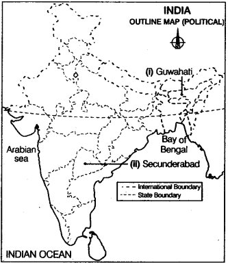
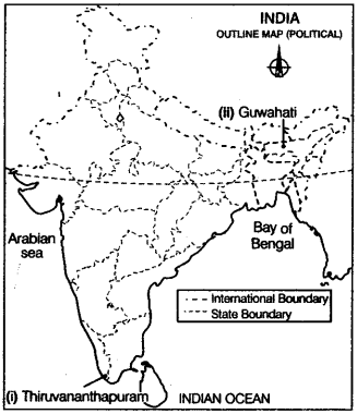
Question 32.
Locate and label the following features with appropriate symbols on the given outline political map of India.
(i) The international airport located in AssAnswer: (All India 2016)
(ii) The headquarter of South Central railway zone. (Delhi 2016)
Answer:
(i) Guwahati
(ii) Secunderabad
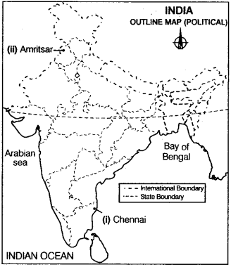
Question 33.
On the given political outline map of India, locate and label the following with appropriate symbols.
(i) The international airport in Punjab. (All India 2015)
OR
The northernmost international airport. (Delhi 2014)
(ii) The international airport in Karnataka. (Delhi 2015)
Answer:
(i) Amritsar
(ii) Bengaluru
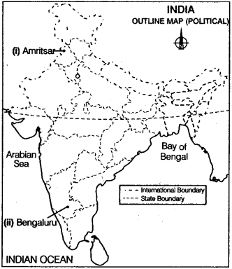
Question 34.
On the given political outline map of India, locate and label the following with appropriate symbols.
(i) The international airport in Tamil Nadu. (All Indio 2014)
(ii) The northernmost international airport. (Delhi 2014)
Answer:
(i) Chennai
(ii) Amritsar
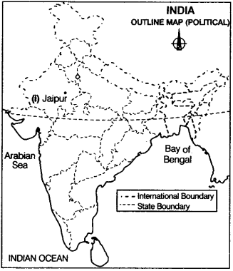
Question 35.
Locate and label the following on the political outline map of India with appropriate symbols.
(i) Headquarter of North-Western Railway zone. (Delhi 2013)
Answer:
(i) Jaipur
Question 36.
On the given political outline map of India provided to you, locate and label the following with appropriate symbols.
(i) The southernmost international airport. (All India 2008)
(ii) The easternmost international airport. (Delhi 2008)
Answer:
(i) Thiruvananthapuram
(ii) Guwahati
Value Based Questions
Question 37.
“International Highways are constructed with the aim to promote a harmonious relationship with neighbouring countries and provide an effective connection with India”. Which value lead to the construction of International Highways?
Answer:
Following values lead to the construction of highways:
- Globalisation
- International peace
- Harmony
Question 38.
“From an economic and strategic point of view, use of satellite is very vital for the country, as these give continuous and synoptic view larger area”. Identify the values from the statement.
Answer:
Following values can be derived from the statement:
- Technological advancement
- National security
- Development